Search Navarro County Property Records, Review the 2026 Appraisal and Pay the Correct Tax Account
Use this guide to locate a Navarro County appraisal account, understand its land and improvement values, check exemptions, use the map, prepare protest evidence and reach the correct property-tax payment system.
Navarro Central Appraisal District determines property values and handles exemptions, special-use appraisal, renditions and appraisal protests. The Navarro County Tax Assessor-Collector handles tax bills, payments, receipts and collections.
Quick Answer: Which Navarro County Office Should You Use?
Use Navarro CAD for
Property values, owner and parcel search, building data, mailing-address changes, exemptions, agricultural appraisal, timber and wildlife forms, business renditions, mapping and protests.
Use the Tax Office for
Current tax balances, online payments, e-check or card payments, mailed payments, tax receipts, penalties, interest and collection questions.
Use the County Clerk for
Recorded deeds, deeds of trust, tax liens, affidavits, UCC records, plats, probate records and official document copies.
Do not protest the tax rate at Navarro CAD: The appraisal district determines taxable property values. Local taxing units adopt rates, and the Tax Office calculates and collects the resulting bills.
Understand a 2026 value
Save the appraisal account, compare 2025 and 2026 and identify whether land, buildings, classification or new improvements caused the change.
Apply for an exemption
Use the official forms page for homestead, disabled-veteran and other applications.
File or check a protest
Use the official online-protest system, Notice of Protest form or Protest Hearing Search.
Pay property taxes
Use the green Pay Taxes button inside a verified appraisal account or open the Tax Office search directly.
Find deed or title records
Use the County Clerk’s official record system for records from 1974 to the present.
Jump Directly to Your Navarro County Property Task
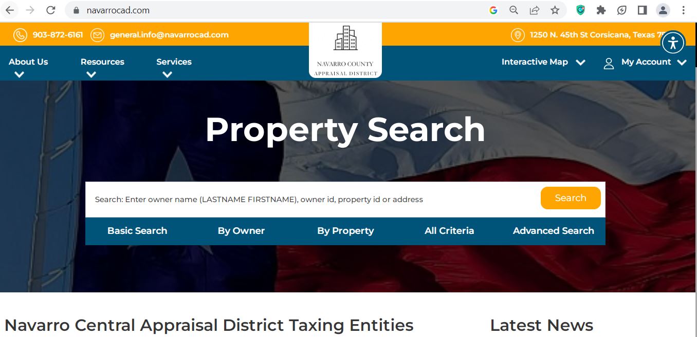
How to Use the Navarro CAD Property Search Screenshot
The supplied screenshot shows the official Navarro Central Appraisal District property-search page. It is more useful than a general homepage screenshot because it shows the actual search box and search tabs.
The image is a navigation guide only. Use the live search before relying on a property owner, value, exemption, protest status or payment balance.
Official Navarro CAD search screen showing the main search bar and five ways to narrow a property search.
1Verify the domain
Check that the browser shows navarrocad.com or esearch.navarrocad.com before entering property information.
2Use Basic Search first
Enter an owner name, owner ID, property ID or address. The screenshot instructs users to enter owner names as last name first name.
3Use By Owner for people or companies
Search a surname, business, trust or estate. Start with one major name rather than the complete legal wording.
4Use By Property for exact records
This tab is useful for property ID, geographic ID, address, legal description, abstract, subdivision and lease details.
5Use All Criteria or Advanced Search
Narrow results by acreage, value, category, property type, neighborhood, abstract, subdivision, protest status or agent.
6Use Interactive Map and My Account
Open the map after identifying the property. Use My Account when accessing online-protest or taxpayer communication features.
Best route from this screenshot: Run a Basic Search, open the likely account, verify five identifying fields, then use the property page’s green Pay Taxes button, map option or protest tools.
Begin with Basic Search.
Enter the owner’s last name, a property ID or a simplified street address.
Shorten the owner name when necessary.
Try only the surname, first name, trust name, estate name or major company word.
Simplify the address.
Use the street number and main street name. Remove Road, Street, Lane, Drive, Highway and directional wording if no result appears.
Use By Property when you have technical details.
Enter the property ID, geographic ID, legal description, abstract, subdivision, lease name or lease number.
Choose the correct tax year.
Select 2026 for the current appraisal. Use prior years only when comparing value, ownership or exemption history.
Select the correct property type.
Do not compare a mineral, business-personal-property, mobile-home or agricultural account as though it were an ordinary residence.
Open every plausible result.
One owner may have a home, lake lot, additional acreage, mineral interest, business account or several separate tracts.
Save a dated copy.
Print or save the property record before filing an exemption, requesting a correction, protesting or paying.
Local search tip: For acreage near Blooming Grove, Frost, Dawson, Kerens, Rice, Richland, Streetman or rural Corsicana, property ID, geographic ID, abstract or owner search may work better than a complete road address.
Five Checks Before You Use a Navarro CAD Result
Do not use the first result simply because the owner name looks familiar. Confirm the account belongs to the exact parcel involved in your form, protest, purchase or payment.
Property ID
Match the number on the notice or tax statement.
Geographic ID
Compare the full location-based account identifier.
Legal description
Match subdivision, abstract, lot, block or tract.
Acreage or address
Confirm the physical property, not only the mailing address.
Property type
Verify real, personal, mineral or mobile-home classification.
Multiple-account warning: A house, adjoining acreage, manufactured home, minerals and business equipment can appear under separate account numbers even when one owner controls all of them.
Navarro CAD Search Problems and Practical Fixes
Problem
What to Try
Why It Helps
Full owner name gives no result
Search only the last name or first name.
The appraisal record may use initials, abbreviations or a different name order.
Recent buyer is not displayed
Search the seller or prior owner.
A deed may be recorded before the appraisal ownership display is updated.
Full address does not work
Use only the main street name or remove the street suffix.
The appraisal situs format may differ from the postal or emergency address.
Too many results appear
Add the property ID, city, abstract, subdivision, acreage or property type.
Advanced criteria separate owners with common names and multiple properties.
Trust or estate is missing
Search the trustee, decedent, estate, trust and former owner separately.
Official ownership wording may not match the name used by the family.
Lake lot cannot be identified
Search the subdivision, lot, owner or adjoining parcel.
A lake property may have a different situs description from its mailing address.
Need a mineral interest
Use Advanced Search with the mineral property type, lease name or lease number.
Mineral and surface estates can have separate owners and accounts.
Property remains missing
Call Navarro CAD with the prior owner, location and legal description.
Staff can help identify the correct property and geographic IDs.
“I am trying to locate the correct Navarro CAD account. The current or prior owner is ______, the property is near ______, and the deed or notice shows ______. Can you confirm the property ID, geographic ID and property type?”
How to Read a Navarro CAD Property Record
Record Field
Plain-English Meaning
What to Check
Property ID
The appraisal district’s primary account number.
Use the exact number on forms, calls, protests and tax searches.
Geographic ID
A location-based identifier assigned in the appraisal system.
Copy the complete number when matching maps or tax records.
Owner and owner ID
The owner currently displayed for appraisal purposes.
Use a recorded deed when legal ownership must be proved.
Mailing address
Where appraisal notices and tax correspondence may be sent.
Submit a mailing-address correction when it is outdated.
Situs address
The physical property location used by the district.
Rural or lake-property situs information may differ from postal formatting.
Legal description
Subdivision, abstract, lot, block, survey or tract information.
Compare it with the deed, plat or survey before legal use.
Land market value
The estimated market value assigned to the land.
Acreage, neighborhood, waterfront influence, land class and homesite allocation.
Improvement value
Value assigned to homes, shops, barns and other structures.
Size, age, quality, condition, use and removed structures.
Market value
The district’s estimate of the property’s January 1 market value.
Compare with sales, condition and similar local properties.
Appraised value
Value after an applicable appraisal limitation.
Do not confuse a cap adjustment with a market-value reduction.
HS cap loss
Difference created by the residence-homestead appraisal cap.
The cap may limit appraised-value growth but does not freeze market value.
Circuit breaker
A possible limitation adjustment for qualifying non-homestead real property.
Ask Navarro CAD whether the account qualifies and how the adjustment was calculated.
Agricultural value
Productivity-based value for qualifying open-space land.
Confirm the correct acreage, use and homesite separation.
Roll value history
Prior-year land, improvement, appraisal and assessed values.
Identify which component caused the current change.
Research-only disclaimer: The official search warns that legal descriptions and acreage are for appraisal-district use and should be independently verified before legal use.
Why a Navarro CAD 2026 Record May Show N/A
Some 2026 records may display N/A for current land, improvement, market or assessed values while prior-year history remains visible.
Current value is not yet displayed
The account may still be in a preliminary, processing or publication stage.
Use the official notice
Review the Notice of Appraised Value delivered for the property when it contains the current proposed value.
Contact the district
Call Navarro CAD when the live record and the mailed notice do not agree or when a deadline depends on the notice.
Do not substitute the 2025 value: A prior-year value is useful for comparison but is not proof of the final 2026 appraisal or taxable value.
Navarro County 2026 Appraisal Audit Checklist
Compare 2025 and 2026 total market value.
Separate the land increase from the building increase.
Verify acreage and homesite allocation.
Check living area and total building area.
Review year built, quality and condition.
Look for a new addition, pool, shop or outbuilding.
Confirm removed or damaged structures are corrected.
Check homestead and other exemptions.
Review HS cap loss or circuit-breaker fields.
Check agricultural market and productivity values.
Compare similar properties in the same market area.
Save dated photographs and repair estimates.
Corsicana homes
Compare similar homes by neighborhood, living area, age, construction quality, condition and lot size.
Richland Chambers Lake property
Check waterfront influence, subdivision, lot identity, improvements and whether adjoining lots have separate property IDs.
Rural land
Review abstract, acreage, homesite, native pasture, cultivated land, access, utilities and qualifying agricultural use.
“Property ID ______ changed from ______ in 2025 to ______ in 2026. Please identify the specific land, improvement, classification or account-data change that caused the difference.”
Find the property record first.
Copy the property ID, geographic ID, owner, legal description and acreage.
Search with the strongest identifier.
Use the property or geographic ID when available. Otherwise, use the owner or location.
Match the selected parcel.
Compare the owner, account, subdivision, abstract, acreage and legal description.
Review adjoining parcels.
Look for separate lots, access strips, road frontage, lake frontage and related ownership.
Check improvements against the appraisal record.
Note visible homes, shops, barns, docks or cleared areas that may affect your research.
Use legal records before acting.
Obtain deeds, title research and a professional survey before fencing, building, dividing or resolving access.
Lake-property tip: An appraisal parcel line does not prove shoreline ownership, easement rights, dock authority or exact waterfront boundaries. Review the deed, plat, restrictions and other responsible authorities.
Navarro County Homestead and Property-Tax Exemptions
Navarro CAD provides residence-homestead affidavits, disabled-veteran forms and other exemption applications. A homestead application must include the applicant’s driver license or other information required by the Texas Property Tax Code.
Exemption or Relief
2026 Starting Point
What to Prepare
General residence homestead
School districts provide a mandatory $140,000 exemption.
Ownership interest, principal-residence information and required identification.
Age 65 or older
Qualifying owners receive an additional mandatory $60,000 school exemption.
Age, ownership and principal-residence information.
Disabled person
Qualifying disabled owners may receive the additional school exemption and related protections.
Documentation accepted under the applicable disability definition.
Disabled veteran or survivor
The benefit may be partial or total depending on the statutory category.
VA rating, service information and applicable survivor documents.
Heir-property homestead
An occupying heir may qualify without being individually named on a recorded deed.
Ownership affidavit, death certificate, utility bill and available court records.
Tax deferral
Certain age-65 or disabled owners may defer collection on a qualifying residence homestead.
Understand that the tax lien remains and interest can continue accruing.
How to File a Navarro CAD Homestead Application
Search and verify the property.
Confirm the property ID, owner, situs address and legal description.
Complete every applicable ownership section.
Include trust, heir-property, manufactured-home or partial-ownership details when relevant.
Attach the required identification.
Ensure the residence information meets the form requirement or provide evidence for an allowed exception.
Submit the complete packet.
Mail or deliver it to Navarro Central Appraisal District, 1250 N. 45th Street, Corsicana, TX 75110. Confirm before using another submission method.
Keep proof of delivery.
Save the complete packet, mailing evidence or stamped copy.
Verify the live property record.
Check that the exemption appears for the correct owner, parcel and tax year after processing.
New-owner reminder: A seller’s homestead exemption and appraisal cap do not automatically transfer to the buyer.
Agricultural, Timber and Wildlife Appraisal in Navarro County
Navarro CAD provides separate applications for 1-d-1 open-space agricultural appraisal, timber land, restricted-use timber, wildlife management plans and annual wildlife reports.
Qualification Area
What Needs to Be Demonstrated
Useful Evidence
Principal agricultural use
Agriculture is the land’s primary qualifying use.
Livestock, grazing, crop, hay, production and sales records.
Degree of intensity
The operation is typical for qualifying land in the local area.
Stocking, fencing, water, feed, machinery and management records.
Qualifying-use history
The statutory history requirement has been met.
Prior applications, leases, receipts, photographs and operator statements.
Timber production
The tract is actively devoted to qualifying timber production.
Management plan, planting, thinning, harvest and expense records.
Wildlife management
The land satisfies the prerequisite appraisal and wildlife-management requirements.
Wildlife plan, annual report, maps, practice logs, receipts and photographs.
Homesite separation
Residential and nonqualifying acreage are separated from productive land.
Survey, aerial image and clear acreage breakdown.
Current 1-d-1 or timber application
Property ID for every tract
Legal description and acreage
Map showing the claimed land
Current agricultural or timber activity
Historical-use records
Lease when another person operates the land
Production, livestock or harvest records
Receipts and dated photographs
Wildlife plan and annual report when applicable
Change-of-use warning: A nonqualifying change in use can create additional tax consequences. Ask Navarro CAD about current rollback-tax rules before subdividing, developing or changing the land’s use.
Business Property, Mineral Interests and Manufactured Homes
Business personal property
Equipment, machinery, furniture, fixtures, computers, tools, vehicles, inventory and supplies may require a rendition.
Mineral and lease accounts
The Navarro search includes lease-name and lease-number fields. Mineral ownership may be separate from the surface estate.
Manufactured homes
The home and land may have separate accounts or different owners. Search both the mobile-home and real-property records.
Business Rendition Preparation
Business legal and trade names
Navarro CAD account number
Physical business location
Asset descriptions
Original acquisition cost
Year acquired
Disposed or retired assets
Leased equipment
Inventory and supplies
Owner or authorized-agent signature
2026 business-property change: Texas law created a $125,000 exemption for qualifying income-producing tangible personal property. Contact Navarro CAD about the local filing or rendition steps before assuming no form is required.
Normal rendition timing: Business-personal-property renditions are generally due April 15. A timely written extension can move the deadline to May 15. Confirm your account’s requirements with Navarro CAD.
How to Prepare a Navarro County CAD Protest
July 2026 timing: The normal spring protest period has generally passed for owners who received timely 2026 appraisal notices. The exact deadline printed on the Notice of Appraised Value controls.
Texas generally uses May 15 or the 30th day after delivery of the notice, whichever is later, for most appraisal protests. Do not calculate the deadline from the day you opened the envelope unless that matches the legal delivery date.
Protest Issue
Evidence That Helps
Weak Argument to Avoid
Market value is too high
Comparable sales, appraisal, repair estimates, photographs and condition evidence.
“My property taxes increased.”
Unequal appraisal
Comparable appraisal accounts adjusted for location, land, size, age, quality and condition.
One unrelated property with a lower value.
Building details are wrong
Measurements, plans, photographs and records showing actual construction.
An unsupported verbal estimate.
Land or acreage is wrong
Deed, survey, plat, terrain, access, flood and use evidence.
Relying only on an approximate GIS line.
Exemption was denied or removed
Application, identification, ownership proof and qualification records.
Assuming an exemption transferred automatically.
Agricultural appraisal was denied
Use history, leases, production, stocking, receipts, maps and photographs.
Read the Notice of Appraised Value.
Record the property ID, proposed value, reason for change and exact deadline.
Save the live appraisal account.
Review the land, improvements, exemptions, value history and property characteristics.
Identify each issue separately.
Separate market value, unequal appraisal, data errors, exemption and special-appraisal arguments.
State the value or result you believe is correct.
Support the requested result with specific evidence instead of asking for an unexplained reduction.
Open the official filing route.
Use Navarro CAD Online Protest or download the Notice of Protest form from the forms page.
Keep proof of timely filing.
Save the portal confirmation, stamped copy or accepted mailing evidence.
Check the hearing schedule.
Use the Protest Hearing Search to review hearing information when available.
Prepare a one-page hearing summary.
List the property, requested value, strongest reasons and supporting exhibit numbers.
“I am reviewing Navarro CAD property ID ______ for tax year 2026. My notice shows a deadline of ______. Please confirm the accepted filing route, evidence instructions and hearing status.”
What to Do After the Regular Protest Deadline
Missing the normal deadline does not create a general second protest period. A limited correction or late-protest remedy may exist depending on the error, notice history and tax-payment status.
Ownership or clerical mistake
Ask whether the account qualifies for an appraisal-roll correction.
Required notice was not received
Explain when the notice was discovered and which mailing address Navarro CAD used.
Substantial appraisal error
A limited statutory correction procedure may apply in narrowly defined circumstances.
Late exemption
Some homestead, age-65, disability and veteran situations have special late-filing provisions.
Incorrect property description
Document the precise acreage, building or duplicate-account error and ask which correction process applies.
Taxes remain unpaid
Contact the Tax Office separately because a value question does not automatically stop penalties or collection.
Process concern: Navarro CAD lists a Taxpayer Liaison Officer contact at tlo@navarrocad.com for taxpayer complaints or suggestions involving the district and ARB process.
Act quickly: Call Navarro CAD with the property ID, tax year, notice history, error description and payment status. Do not wait for another bill cycle while investigating a possible remedy.
How to Search and Pay Navarro County Property Taxes
The appraisal search can send a verified property to the payment system through a green Pay Taxes button. The actual payment account is maintained by the Navarro County Tax Assessor-Collector.
Locate the correct appraisal account.
Search at Navarro CAD and confirm the property ID and legal description.
Choose the green Pay Taxes button.
The official appraisal cart states that this feature can work with multiple properties.
Payment methods
The portal lists Visa, Mastercard, Discover, American Express and e-check.
Standard Texas deadline: Property taxes are normally due by January 31 and become delinquent February 1. Follow the date printed on the actual statement when a special postponed delinquency date applies.
2026 bill timing: Final 2026 tax rates are generally adopted later in the year. Do not use a displayed 2025 rate as proof of the final 2026 bill.
“I need the current payoff for Navarro County tax account ______ through ______. Please confirm every unpaid year, penalty, interest, collection charge and accepted payment method.”
Navarro County 2026 Property-Tax Timeline
January 1
General appraisal date for property value and ownership conditions.
Spring
Appraisal notices, exemption review and regular protest filing period.
August–September
Local tax-rate proposals, hearings and adopted-rate updates generally become available.
Fall and winter
Tax statements are prepared, payments begin and January 31 is the normal deadline.
Tax-rate reminder: A lower tax rate does not always mean a lower bill when taxable value changes. Review both the certified taxable value and every taxing unit’s adopted rate.
Navarro CAD vs Tax Office vs County Clerk
Your Task
Correct Starting Office
Why
Search owner or property value
Navarro Central Appraisal District
The district maintains appraisal accounts and values.
Correct land or building data
Navarro Central Appraisal District
The district maintains appraisal characteristics.
Apply for exemption or special appraisal
Navarro Central Appraisal District
The chief appraiser reviews qualification.
Protest a value or denial
Navarro CAD / Appraisal Review Board
The ARB hears qualifying appraisal disputes.
Pay taxes or obtain receipt
Navarro County Tax Assessor-Collector
The Tax Office bills and collects property taxes.
Find deed, lien or deed of trust
Navarro County Clerk
The Clerk records official real-property instruments.
Confirm legal boundary
Licensed surveyor
CAD and GIS parcel lines are not legal boundary surveys.
Complete title examination
Title company or attorney
One appraisal or deed record does not disclose every title issue.
How to Search Navarro County Deeds and Official Property Records
The County Clerk preserves deeds, tax liens, deeds of trust, affidavits, UCC records and other official public records. Deed recording in Navarro County began in 1850.
Save the appraisal information.
Copy the owner, legal description, subdivision, abstract and property ID from Navarro CAD.
Civil Department
Basement Suite 001A
8:00 a.m.–4:30 p.m.
Recording cutoff
Official public-record filings submitted after 4:00 p.m. are filed the next business day.
Fraud notification
The Clerk offers a free Fraud Notify registration service.
Title warning: Finding one deed does not prove that no mortgage, tax lien, easement, mineral reservation, probate issue or later filing affects the property.
Navarro County Property Buyer and New-Owner Checklist
Appraisal record
Property and geographic ID
Owner and mailing address
Legal description
Acreage and land class
Building details
Every related account
Taxes and exemptions
Current tax balance
Prior-year taxes
Penalty and interest
Homestead status
Agricultural appraisal
Deferral or payment status
Title and land research
Latest recorded deed
Liens and deeds of trust
Easements and restrictions
Survey and legal access
Flood and drainage information
Utilities, septic and permits
Purchase-year warning: Do not estimate your future bill only from the seller’s current taxes. The seller may have a homestead cap, age-65 ceiling, veteran exemption or agricultural appraisal that will not transfer automatically.
Practical Navarro County Property Scenarios
Corsicana residence
Check building size, condition, homestead status, city taxing unit, school district and new improvements.
Richland Chambers Lake property
Verify the subdivision, lot, adjoining parcels, waterfront influence, improvements and recorded restrictions.
Blooming Grove or Frost acreage
Match every tract, homesite acreage, agricultural use and road access.
Kerens, Rice or Streetman property
Confirm city, school, road-and-bridge, flood-control and other taxing entities attached to the account.
Mineral interest
Search by property type, lease name or lease number and do not assume the surface owner also owns the minerals.
Inherited family land
Compare the CAD owner with probate and recorded documents. Changing the mailing address does not complete legal title work.
Navarro County Property Office Contacts
Values, exemptions and protestsNavarro Central Appraisal District
1250 N. 45th Street
Corsicana, TX 75110
Civil Department:
Basement Suite 001A
8:00 a.m.–4:30 p.m.
County Clerk: Sherry Dowd
Before visiting: Call the responsible office to confirm holiday closures, current hours, required identification, accepted submission methods and payment types.
Navarro Central Appraisal District Office Map
Use this map for directions to Navarro CAD at 1250 N. 45th Street in Corsicana.
Use the live official record
Return to the responsible official portal whenever you need a current owner, value, balance, deadline, map or filing status.
Navarro County CAD Property Search FAQs
1. What is the official Navarro County CAD website?
The official Navarro Central Appraisal District website is navarrocad.com. The direct property-search system is esearch.navarrocad.com.
2. Where is Navarro Central Appraisal District located?
Navarro Central Appraisal District is located at 1250 N. 45th Street, Corsicana, Texas 75110. Its main phone number is 903-872-6161.
3. Who is the Navarro CAD Chief Appraiser?
The official Navarro CAD contact page lists Bud Black, RPA, RTA, CTA as Chief Appraiser.
4. How do I search Navarro County property records?
Open the official property search and use Basic Search, By Owner, By Property, All Criteria or Advanced Search. Start with fewer words, then verify the property ID, geographic ID, legal description, address or acreage and property type.
5. Why does my Navarro CAD 2026 property record show N/A?
A current value may not yet be displayed while the account is being processed or published. Use the official appraisal notice and contact Navarro CAD when the live record and notice do not agree.
6. What was the normal Navarro County 2026 protest deadline?
Texas generally uses May 15 or the 30th day after delivery of the Notice of Appraised Value, whichever is later. The exact deadline printed on the individual notice controls.
7. What are the 2026 Texas school homestead exemptions?
School districts provide a mandatory $140,000 general residence-homestead exemption. Qualifying owners age 65 or older or disabled receive an additional mandatory $60,000 school exemption.
8. Where do I pay Navarro County property taxes?
Use the Navarro County Tax Assessor-Collector’s official payment system. The portal lists a 2.3% convenience fee for credit-card payments and a $1.00 fee for e-check payments.
9. Is the Navarro CAD map legal proof of property boundaries?
No. Navarro CAD records and maps are appraisal-research tools. Use recorded documents, a title examination and a licensed surveyor for legal ownership, access and boundary questions.
10. How do I search Navarro County deeds online?
Use the Navarro County Clerk’s official property-record system for records from 1974 to the present. Search all possible grantor and grantee name spellings, then match the legal description and review the underlying document.
Independent Guide Disclaimer
County-CAD.org is an independent informational guide. It is not affiliated with Navarro Central Appraisal District, the Navarro County Appraisal Review Board, Navarro County Tax Assessor-Collector, Navarro County Clerk, any taxing unit or the State of Texas.
Property values, exemptions, deadlines, office personnel, office hours, portal availability, payment charges, balances, forms and tax rates can change. Confirm time-sensitive information with the responsible official office before filing, paying, mailing documents, purchasing property or taking legal action.