
Search Rains County Property Records, Review 2026 Appraisal Values and Pay Property Taxes
Use this guide to locate a Rains County appraisal account, understand the value shown in the official record, check exemptions, open the parcel map, prepare a protest and reach the correct tax-payment option.
Rains County Appraisal District is unusual compared with some Texas counties because its official search system also provides property-tax payment access. The Rains County Tax Assessor-Collector page directs property-tax information questions back to Rains CAD.
Start Here: Choose the Task You Need to Complete
Do not open every county page and hope one contains the answer. Start with the task that matches your situation.
Jump Directly to Your Rains County Property Task
How to Use the Official Rains CAD Website Screenshot
The screenshot below shows the official Rains County Appraisal District homepage. It is included to help you recognize the correct website and choose the right top-level tool.
The screenshot is an orientation guide only. Do not use a saved image as proof of a live value, payment balance, exemption approval, protest status or tax receipt.
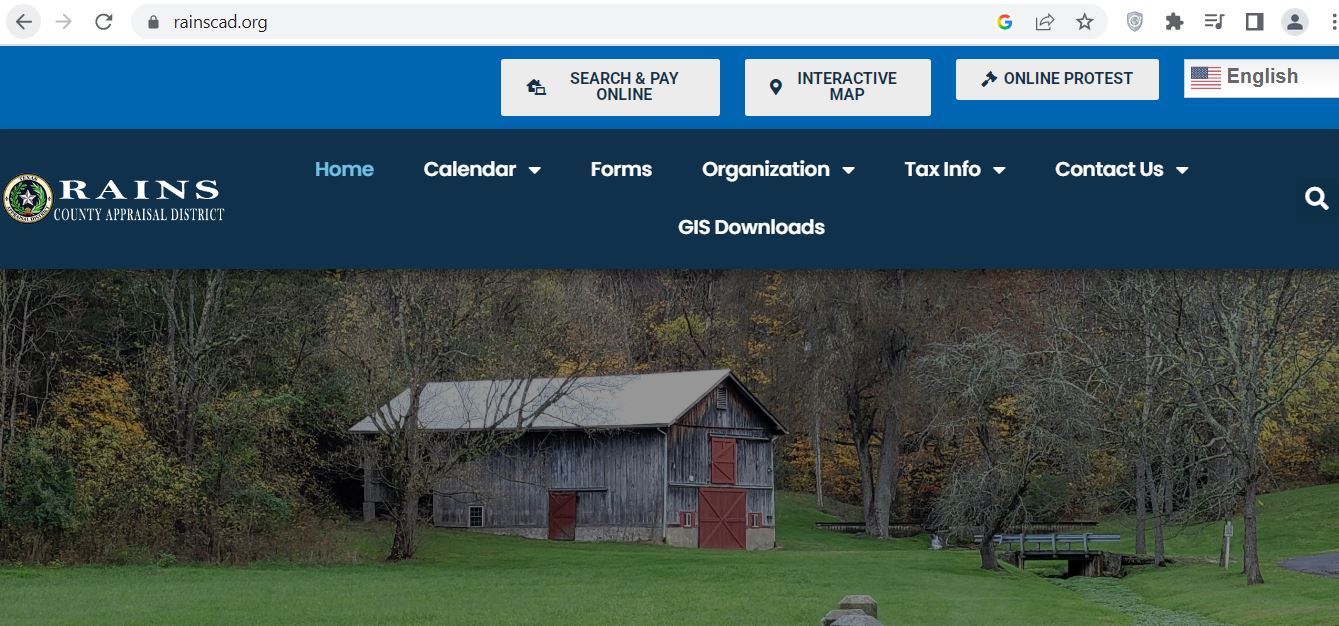
Confirm that the browser address shows rainscad.org before entering property information or opening a payment page.
Use this button for owner, address and property-ID searches. After opening a matching account, look for the green tax-payment option.
Use the map after locating the appraisal account. Match the owner, property ID and legal description before trusting the selected parcel.
Use the official protest button during an eligible filing period. Keep the Notice of Appraised Value available because the printed deadline controls.
Choose Forms for homestead exemptions, agricultural applications, renditions, protest forms, agent appointments and deferral affidavits.
Use Tax Info for appraisal deadlines, exemptions, protest procedures and tax-related educational material.
How to Search Rains County CAD Property Records
The official Rains CAD search includes Owner, Address, ID, ARB Search and Advanced options. It can also identify real, personal, mineral, automobile and mobile-home accounts.
What to Do When the Rains CAD Search Returns Nothing
| Search Problem | Try This | Why It Often Works |
|---|---|---|
| Full owner name gives no result | Search only the surname, then try the first name separately. | The appraisal record may use initials, a shortened name or a different name order. |
| Recent buyer is missing | Search the seller or prior owner and compare County Clerk deed records. | A recorded deed and the appraisal ownership display may update at different times. |
| Full street address fails | Use only the street name or remove Road, Street, Drive, Lane and directional abbreviations. | The official situs format may differ from the mailing or 911 address. |
| Too many owner results | Add the street name, subdivision, property type, geographic ID or tax year in Advanced Search. | Additional fields narrow common surnames and owners with several accounts. |
| Trust, estate or company is missing | Search the trust name, trustee, estate, decedent, company name and prior owner separately. | The official ownership style may not match the everyday name used by the family or business. |
| Manufactured home is missing | Search the home owner and landowner separately and select Mobile Home in Advanced Search. | The manufactured home and land may appear as separate appraisal accounts. |
| Need a mineral or business account | Choose Mineral or Personal under Property Type. | A real-property search may exclude the account type you need. |
| Property still cannot be found | Call Rains CAD with the owner, approximate location, prior owner and legal description. | Staff can search with internal information that may not be obvious in the public interface. |
How to Read a Rains County CAD Property Record
Do not stop after seeing one large value. Review the identification fields, land and improvement data, exemptions, value history and tax section.
| Record Field | Plain-English Meaning | What You Should Verify |
|---|---|---|
| Property ID | The appraisal account identifier. | Use the exact number on forms, calls, protests and payments. |
| Owner name | The owner currently shown on the appraisal roll. | Compare with the newest recorded deed when legal ownership matters. |
| Mailing address | The address used for appraisal and tax correspondence. | Correct it quickly when notices are going to a former address. |
| Situs address | The physical location used for appraisal purposes. | Rural situs information may not match postal formatting exactly. |
| Legal description | Subdivision, lot, block, survey, abstract or tract information. | Match it with the deed, survey or plat before relying on the account. |
| Land details | Acreage, land class, homesite, market value and productive value. | Acreage, homesite area, agricultural use and land category. |
| Improvements | Homes, buildings and other appraised structures. | Size, age, quality, condition, use and removed or missing improvements. |
| Roll value history | Prior-year land, improvement, appraisal and assessed values. | Identify which component caused the 2026 change. |
| HS cap loss | Difference created by an applicable residence-homestead appraisal limit. | A cap can reduce appraised value but does not prove the market value is correct. |
| Estimated tax due | Tax information associated with the appraisal account. | Confirm tax year, taxing units, balance, penalties and payment posting. |
Market Value, Appraised Value, Assessed Value and Taxable Value
How to Investigate a 2026 Value Increase
- Compare 2025 and 2026 land market values.
- Compare improvement value and building details.
- Check whether a new structure or addition was added.
- Confirm homestead and other exemptions remain present.
- Check the homesite and non-homesite acreage split.
- Review agricultural or productive-value fields.
- Compare the property condition with the CAD description.
- Save comparable sales and repair evidence.
How to Pay Rains County Property Taxes Online
The official Rains CAD homepage states that property owners can pay in person, by mail, online or by telephone. The property-search cart explains that users should locate the property and select the green Pay Taxes button.
Rains County Homestead and Property-Tax Exemptions
Applications are filed with Rains County Appraisal District. The district’s forms page states that a homestead application must include a copy of the applicant’s driver license or other information required by the Texas Property Tax Code.
| Exemption or Relief | 2026 Starting Point | Preparation Tip |
|---|---|---|
| General residence homestead | Texas school districts provide a mandatory $140,000 general residence-homestead exemption. | Confirm ownership interest, principal-residence use and matching identification. |
| Age 65 or older | School districts provide an additional mandatory $60,000 exemption for a qualifying owner. | Apply when eligibility begins and ask about the school-tax ceiling. |
| Disabled person | Qualifying disabled owners may receive the additional school exemption and related protections. | Prepare disability documentation accepted under Texas requirements. |
| Disabled veteran or survivor | The amount depends on the qualifying veteran or survivor category. | Keep VA documentation, disability rating and survivor documents available. |
| Tax deferral | Certain age-65 or disabled homeowners may qualify to defer collection on a residence homestead. | A deferral is not a tax cancellation; review interest and later repayment consequences. |
| Disaster-related relief | A temporary exemption may be available when statutory disaster requirements are met. | Save dated photographs, repair estimates, insurance material and damage records. |
Homestead Application Micro-Steps
Agricultural, Timber and Wildlife Appraisal in Rains County
Special appraisal can value qualifying land according to productive capacity instead of unrestricted market value. Rural location, acreage, trees, a pond or occasional livestock does not automatically establish qualification.
| Qualification Area | What Usually Needs to Be Shown | Useful Evidence |
|---|---|---|
| Primary agricultural use | Agriculture is the land’s principal qualifying use. | Livestock, hay, crops, grazing, leases and production records. |
| Degree of intensity | The operation is typical for the local area. | Stocking, fencing, water, feed, equipment and management records. |
| Historical use | The required qualifying-use history exists. | Prior applications, leases, receipts, photographs and affidavits. |
| Timber appraisal | The land is actively used for qualifying timber production. | Management plan, planting, thinning, harvest and expense records. |
| Wildlife management | The land qualifies for the required prior appraisal and uses qualifying wildlife practices. | Wildlife plan, maps, logs, receipts and dated photographs. |
| Homesite separation | Residential and nonqualifying areas are separately identified. | Survey, aerial map and acreage breakdown. |
2026 Rains County Business Personal Property Guidance
Rains CAD’s 2026 business-personal-property flyer highlights a significant local filing issue for businesses, self-employed workers and independent drivers offering goods or services, including operations based from a home.
- Furniture, counters, shelving and displays
- Computers, printers and communication equipment
- Tools, machinery and production equipment
- Inventory and supplies
- Leased or rented equipment at the location
- Business vehicles and specialized units
- Assets used by a home-based business
- Assets of related entities at the same address
Read the official Rains CAD 2026 BPP flyer and use the current form from the official forms page.
How to Prepare a Rains County CAD Protest
Texas generally uses May 15 or the 30th day after delivery of the appraisal notice, whichever is later, for most protests. Rains CAD’s 2025–2026 reappraisal plan shows a primary 2026 protest period extending through May 31. Because official documents may describe different portal windows or property categories, use the deadline printed on your own notice and ask Rains CAD when uncertain.
Evidence That Can Strengthen a Protest
| Protest Issue | Useful Evidence | Weak Argument to Avoid |
|---|---|---|
| Market value is too high | Comparable sales, appraisal, photographs, repair estimates and condition evidence. | “My tax bill increased.” |
| Unequal appraisal | Comparable appraisal records adjusted for size, age, land, quality and condition. | Using one unrelated low-value property. |
| Incorrect building data | Measurements, photographs, plans and records showing actual construction. | A statement with no measurements or documentation. |
| Land or acreage error | Deed, survey, plat, access limits, flood or terrain evidence. | Relying only on an approximate online map line. |
| Exemption denial | Application, identification, ownership proof and qualification documents. | Assuming an exemption transfers automatically from the seller. |
| Agricultural denial | Use history, leases, production, stocking, receipts, maps and dated photographs. | “The property is rural and has animals.” |
Rains CAD Protest Micro-Steps
What to Do When the Normal Protest Deadline Has Passed
A missed regular deadline does not mean every correction route is available, but certain limited remedies may apply depending on the error and tax status.
How to Use the Rains CAD Interactive Parcel Map
The GIS map is useful for general parcel location, nearby accounts, roads and appraisal research. It is not proof of an exact boundary, ownership, easement, legal access, utilities or buildability.
Rains CAD vs Tax Assessor-Collector vs County Clerk
| Your Task | Correct Starting Office | Why |
|---|---|---|
| Search owner, property or appraisal value | Rains County Appraisal District | Rains CAD maintains the appraisal account and property-search system. |
| Apply for homestead or agricultural appraisal | Rains County Appraisal District | The chief appraiser decides appraisal-district exemption and special-appraisal applications. |
| File an appraisal protest | Rains CAD / Appraisal Review Board process | The ARB hears qualifying property-owner protests. |
| Pay Rains County property taxes | Rains CAD Search & Pay system | The official Rains CAD website provides online, telephone, mail and in-person payment instructions. |
| Vehicle title or registration | Rains County Tax Assessor-Collector | The county page identifies the office as the Department of Motor Vehicles service office. |
| Deed, lien, easement or recorded document | Rains County Clerk | The Clerk records real-property instruments and provides official copies. |
| Exact boundary or legal access | Surveyor or title professional | An appraisal map is not a boundary survey or title opinion. |
Rains County Property Office Contacts
Emory, TX 75440
Mailing: P.O. Box 70
Emory, TX 75440
Phone: 903-473-2391
Fax: 903-473-4040
Email: rcadmail@rainscad.org
Chief Appraiser: Sherri McCall
167 E. Quitman Street, Suite 103
Emory, TX 75440
Phone: 903-473-5018
Email: nicole.york@co.rains.tx.us
Monday–Friday: 8:00 a.m.–4:30 p.m.
Closed for lunch: noon–1:00 p.m.
Courthouse Annex
220 W. Quitman Street, Suite B
Emory, TX 75440
Phone: 903-473-5000, extension 103
Use this office for deeds, liens, easements, plats, releases and official recorded-document copies.
Rains County Appraisal District Office Map
Use this map for directions to the Rains CAD office at 145 Doris Briggs Parkway in Emory.
Rains County Property Buyer and Owner Checklist
- Correct property ID
- Owner and mailing address
- Legal description
- Acreage and property type
- Land and improvements
- Every related account
- Current and prior balances
- Penalty and interest
- Payment posting
- Homestead status
- Age-65 or disability benefits
- Deferral or payment arrangement
- Current recorded deed
- Liens and deeds of trust
- Easements and restrictions
- Survey and physical access
- Floodplain and drainage
- Septic, utilities and road access
Practical Rains County Property Scenarios
Official Rains County Property Resources
Rains County CAD Property Search FAQs
1. What is the official Rains County CAD website?
The official Rains County Appraisal District website is rainscad.org. Its homepage provides links to the property search and payment system, interactive map, online protest option, forms, tax information and contact details.
2. Where is Rains County Appraisal District located?
Rains County Appraisal District is located at 145 Doris Briggs Parkway, Emory, Texas 75440. Its mailing address is P.O. Box 70, Emory, Texas 75440.
3. What is the Rains CAD phone number?
The main Rains County Appraisal District telephone number is 903-473-2391. The district also lists rcadmail@rainscad.org for general email contact.
4. Who is the Rains County Chief Appraiser?
The official Rains CAD staff page lists Sherri McCall as Chief Appraiser.
5. How do I search Rains County property records by owner or address?
Open the official Rains CAD Property Search and select Owner, Address or ID. Search the owner as last name first, or begin an address search with the main street name. Confirm the result using the property ID and legal description.
6. Can I pay Rains County property taxes through Rains CAD?
Yes. The official Rains CAD website provides online, telephone, mail and in-person payment information. For online payment, locate the correct property account and select the green Pay Taxes button.
7. What do market value, appraised value and HS cap loss mean?
Market value is the district’s market-value estimate. Appraised value reflects an applicable appraisal limitation. HS cap loss shows the difference created by the qualifying residence-homestead appraisal cap. A cap does not freeze the market value.
8. What was the regular Rains County 2026 appraisal-protest deadline?
The exact deadline printed on the property owner’s Notice of Appraised Value controls. Texas generally uses May 15 or 30 days after delivery of the notice, whichever is later, while Rains CAD’s 2025–2026 reappraisal plan shows a primary 2026 protest period ending May 31.
9. What is the 2026 Texas school homestead exemption?
Texas school districts provide a mandatory $140,000 general residence-homestead exemption. Qualifying owners who are age 65 or older or disabled receive an additional mandatory $60,000 school-district exemption.
10. Is the Rains CAD map or property record legal proof of ownership or boundaries?
No. Rains CAD records and GIS maps support appraisal research but do not replace an official recorded deed, title examination, plat or professional boundary survey.
Independent Editorial Notice
County-CAD.org is an independent informational guide. It is not affiliated with Rains County Appraisal District, the Rains County Appraisal Review Board, Rains County, the Tax Assessor-Collector, County Clerk, any city, school district, emergency-service district or the State of Texas.
Property values, exemptions, protest deadlines, tax balances, payment charges, office personnel, office hours, forms and online systems can change. Verify time-sensitive information with the responsible official office before filing, mailing, paying, buying property or taking legal action.
Editorial verification: July 23, 2026. Information was reviewed against the official Rains CAD homepage, property-search portal, taxpayer portal, forms, exemption-deadline information, staff and contact pages, Rains County office pages and current Texas Comptroller property-tax guidance.
Slug: rains-county-cad