Search Marion County Texas Property Records, Review the 2026 Appraisal and Pay the Correct Tax Account
Use this guide to find a Marion County appraisal account, understand its land and improvement values, check homestead or agricultural treatment, prepare protest evidence and reach the separate county tax-payment system.
Marion Central Appraisal District determines market values and administers exemptions, agricultural or timber appraisal, business-property renditions and protests. The Marion County Tax Assessor-Collector prepares tax bills and collects payments.
Quick Answer: Which Marion County Office Do You Need?
Use Marion CAD for
Property search, appraised value, owner and mailing-address display, building data, exemptions, agricultural or timber valuation, business personal property, parcel mapping and protests.
Use the Tax Office for
Tax statements, payment balances, online payments, partial payments, receipts, penalty, interest, installment agreements, rendition-penalty collection and delinquent-tax questions.
Use the County Clerk for
Recorded deeds, liens, releases, easements, plats, probate documents, official copies and property-fraud alerts.
Important distinction: Marion CAD does not set tax rates and does not collect the annual property-tax bill. Taxing units adopt rates, and the Tax Assessor-Collector calculates and collects the resulting tax.
Review a 2026 appraisal
Save the property record and identify whether land, improvements, classification, new construction or exemption changes caused the difference.
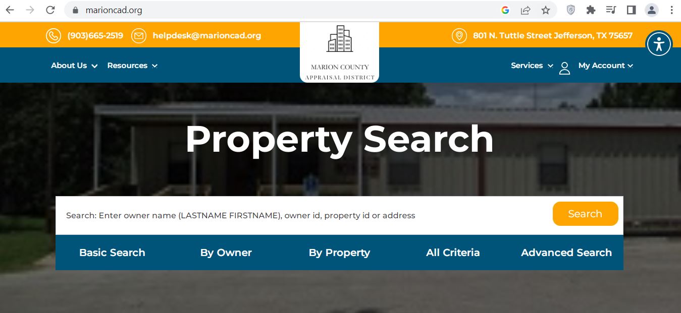
The supplied image shows the live Marion Central Appraisal District property-search page. It includes the district’s phone, email, office address, search box and five search methods.
Use the screenshot to recognize the correct page, but use the live system before relying on a current owner, value, exemption, map or tax amount.
Official Marion CAD property-search screen with the main search box and five ways to narrow a property lookup.
1Confirm the domain
The browser should show marioncad.org. The header should list 903-665-2519 and 801 N. Tuttle Street in Jefferson.
2Use the large search box
Enter an owner name in last-name-first-name order, an owner ID, property ID or simplified address.
3Choose Basic Search first
This is the fastest option when you have one clear name, address or account identifier.
4Use By Owner or By Property
By Owner gives more name and mailing fields. By Property adds geographic ID, legal description, address, abstract and subdivision fields.
5Use All Criteria
Combine property and owner details when a common surname or rural address produces too many results.
6Use Advanced Search carefully
Narrow records by category, acreage, value, tax year or property type without accidentally excluding the correct account.
Fastest path from the screenshot: Run a Basic Search, open the likely result, copy the property ID and geographic ID, and then use those numbers for the map, protest form or Tax Office search.
Start with the strongest identifier.
Use the property ID or geographic ID from an appraisal notice, prior record or tax bill when available.
For owner searches, enter the surname first.
Begin with only the last name. Add the first name after reviewing the initial results.
For address searches, simplify the entry.
Use the street number and main street name. Remove Road, Drive, Lane, Highway, direction and unit wording if nothing appears.
Choose the correct property type.
Real property, business personal property, minerals and manufactured homes can appear under separate accounts.
Select tax year 2026.
Use previous years only when comparing value, ownership or exemption history.
Open every plausible result.
One owner may have a residence, adjoining acreage, vacant lake lot, timber tract, mineral account, manufactured home or business account.
Match the legal description.
Confirm subdivision, section, lot, abstract, survey, tract or acreage.
Save a dated copy.
Print or save the complete record before filing, protesting, purchasing or paying.
Local search tip: For property around Jefferson, Lake O’ the Pines, Avinger, Gray, Smithland, Lodi or rural Marion County, the property ID, geographic ID, abstract or subdivision may work better than a fully formatted road address.
Five Checks Before You Use a Marion CAD Result
Property ID
Match the number on the notice or bill.
Geographic ID
Compare the full location-based identifier.
Legal description
Match lot, block, abstract, survey or tract.
Situs or acreage
Confirm the physical property—not the mailing address.
Property type
Verify real, personal, mineral or manufactured housing.
Multiple-account warning: The surface estate, mineral interest, manufactured home, business equipment and adjoining land can each have a different property ID.
Marion CAD Search Problems and Practical Fixes
Search Problem
What to Try
What to Verify
Full owner name returns nothing
Search only the surname or first name.
The record may use initials, a prior name or last-name-first formatting.
Recent buyer is not shown
Search the seller or prior owner.
Compare the CAD record with the latest recorded deed.
A full rural address fails
Use only the street number and main road name.
The appraisal situs format may differ from the postal or 911 address.
Too many records appear
Add a subdivision, abstract, geographic ID, acreage range or property type.
Do not select a parcel only because the owner name matches.
Trust or estate is missing
Search the trustee, decedent, estate, trust and former owner separately.
Tax-roll wording may differ from how the family describes ownership.
Lake lot cannot be identified
Search by subdivision, section, lot or adjoining owner.
Several nearby lots can share similar street descriptions.
Manufactured home is missing
Search the home owner and landowner separately.
The home and land may have separate accounts or ownership.
Property still cannot be found
Call Marion CAD with the prior owner, location and deed description.
Ask staff to confirm the property ID, geographic ID and property type.
“I am trying to identify the correct Marion CAD property account. The current or prior owner is ______, the property is near ______, and the deed or tax document shows ______. Can you confirm the property ID, geographic ID and property type?”
How to Read a Marion CAD Property Record
Record Field
Plain-English Meaning
What to Check
Parcel or property ID
The district’s primary account identifier.
Use the exact number on forms, protests, calls and tax searches.
Geographic ID
A location-based account number used in appraisal records.
Copy all digits and separators when matching map or tax data.
Owner and owner ID
The owner currently displayed on the appraisal roll.
Use a recorded deed when legal ownership must be proved.
Mailing address
Where appraisal and tax correspondence may be sent.
File an address change before notices or bills are missed.
Location
The physical or situs address used by the district.
Rural and lake-property descriptions may differ from postal formatting.
Legal description
Subdivision, lot, section, abstract, survey or tract information.
Compare it with the deed, plat or survey before legal use.
Category code
The appraisal classification assigned to the account.
Confirm whether the parcel is residential, vacant, commercial, agricultural or another type.
Land market value
The district’s estimated market value for the land.
Acreage, homesite, waterfront influence, land class, access and utilities.
Productivity value
Special value for qualifying agricultural or timber land.
Confirm the correct acreage and use are receiving special appraisal.
Improvement value
Value assigned to houses, cabins, shops, barns or other structures.
Size, age, class, condition and removed or damaged buildings.
Market value
The district’s January 1 estimate of market value.
Compare with sales, condition and similar local properties.
Taxable value
Value after exemptions, caps or special appraisal adjustments.
Confirm every approved exemption appears under the correct taxing units.
Taxing jurisdictions
County, road-and-bridge, city, school and hospital entities attached to the parcel.
A parcel near a boundary may not have the taxing units you expected.
Deed history
Basic transfer references connected to the account.
Use the County Clerk’s actual recorded document for legal research.
Official portal warning: Marion CAD states that legal descriptions and acreage are provided for appraisal-district use and should be independently verified before being used in legal documents.
What Is Different About Marion County’s 2026 Reappraisal Work?
Marion CAD’s latest annual appraisal report scheduled the western side of the county—identified as reappraisal area RA1—for the 2026 cycle. District records also show that field appraisal work for 2026 began during 2025.
West-side parcels
Owners may see closer review of land class, buildings, site improvements and property characteristics during the scheduled cycle.
New construction countywide
New homes, additions, shops, manufactured homes and other improvements can be discovered and added regardless of the rotating reappraisal area.
Demolished or damaged structures
Owners should provide dated evidence when a building was removed, damaged or is no longer usable.
Sales analysis
Marion CAD uses available sales, cost information and neighborhood analysis when developing mass-appraisal schedules.
Mineral and industrial accounts
The district states that mineral, utility and industrial accounts are appraised through a contracted appraisal firm.
Real and personal property
Ordinary real estate and business-personal-property accounts are appraised locally by the district.
2026 Appraisal Audit Checklist
Compare 2025 and 2026 total market value.
Separate land changes from improvement changes.
Verify the exact acreage and legal tract.
Check waterfront or subdivision classification.
Review living area, year built and condition.
Look for newly added shops, cabins or barns.
Confirm demolished structures were removed.
Check homestead and veteran exemptions.
Review agricultural or timber productivity acreage.
Compare similar properties in the same market area.
Photograph damage and deferred maintenance.
Keep repair estimates and inspection reports.
“Property ID ______ changed from ______ in 2025 to ______ in 2026. Please explain which land, improvement, classification, reappraisal or account-data change caused the difference.”
How to Use the Marion CAD Parcel Map
Find the property record first.
Copy the property ID, geographic ID, owner, legal description and acreage.
Use a current browser.
If the map displays a browser-support message, open it in a current version of Chrome, Edge or Firefox and allow scripts.
Search with the strongest identifier.
Use the property or geographic ID when supported. Otherwise use the owner or location.
Match the selected parcel.
Compare the owner, parcel number, subdivision, abstract, legal description and acreage.
Review adjoining accounts.
Look for separate lake lots, access strips, roads, timber tracts and related ownership.
Use recorded records before acting.
Obtain the deed, plat, title research and a professional survey before fencing, building or resolving access.
Lake and rural property tip: An online parcel line does not prove shoreline ownership, easement rights, road access or exact acreage. Match the GIS result with recorded documents and a survey.
Marion County Homestead and Property-Tax Exemptions
Exemption applications are filed with Marion Central Appraisal District. The district’s forms page includes the residence-homestead application and states that required identification or supporting affidavits must accompany the application.
Exemption or Relief
2026 Starting Point
What to Prepare
General residence homestead
Texas school districts provide a mandatory $140,000 exemption on a qualifying residence homestead.
Ownership interest, principal-residence information and required identification.
Age 65 or older
Qualifying owners receive an additional mandatory $60,000 school exemption and may qualify for tax ceilings.
Age, ownership and residence information.
Disabled person
Qualifying disabled owners may receive the additional school exemption and applicable ceiling protection.
Documentation meeting the Texas disability standard.
Disabled veteran
Partial or total relief can apply depending on the statutory category and VA determination.
VA documentation, service information and survivor records when applicable.
Heir-property homestead
An occupying heir may qualify even when not individually named on a recorded deed.
Ownership affidavit, death certificate, utility records and available court documents.
Local optional exemptions
County, road, city and school benefits can differ by taxing unit.
Check the live account instead of assuming every entity grants the same reduction.
Homestead Application Micro-Steps
Find the correct property ID.
Verify the owner, situs address and legal description before completing the form.
Complete every ownership section.
Include trust, heir-property, partial-interest or manufactured-home information when relevant.
Attach the required identification.
The district states that homestead applications must include a driver license copy or other information required by law.
Mail or deliver the packet.
The forms page lists Marion Central Appraisal District, 801 N. Tuttle Street, Jefferson, TX 75657.
Keep proof of submission.
Save the entire application, attachments and delivery evidence.
Verify the approved exemption.
Reopen the live account and confirm the benefit appears for the correct owner, parcel and year.
Late-filing possibility: Texas law allows certain residence-homestead applications to be filed after the normal deadline. Contact Marion CAD rather than assuming the benefit is permanently lost.
Agricultural, Timber and Wildlife Appraisal in Marion County
Marion County contains substantial rural, agricultural and timber land. Marion CAD’s forms page includes separate agricultural and timber applications, questionnaires, procedural guidance and local minimum-acreage information.
Qualification Area
What Needs to Be Demonstrated
Useful Evidence
Primary qualifying use
Agriculture or timber production is the land’s principal qualifying activity.
Production, livestock, grazing, crop, timber and sales records.
Degree of intensity
The activity meets local standards for a typical commercial operation.
Stocking, fencing, water, feed, equipment and management records.
Historical use
The tract has the required qualifying-use history.
Prior applications, leases, receipts, aerials and dated photographs.
Timber management
The land is actively managed for qualifying timber production.
Management plan, planting, thinning, harvest and expense records.
Wildlife management
The property satisfies the prerequisite appraisal and qualifying wildlife practices.
Wildlife plan, activity logs, maps, receipts and photographs.
Homesite separation
Residential acreage and nonqualifying improvements are separated from productive land.
Survey, aerial map and acreage breakdown.
Current agricultural or timber application
Property ID for every tract
Legal description and acreage
Map showing the claimed area
Description of current qualifying use
Historical-use evidence
Lease when another person operates the land
Production or harvest records
Expense questionnaire and receipts
Dated photographs
Wildlife-management plan when applicable
Explanation of any use change
Change-of-use warning: Converting qualifying agricultural or timber land to a nonqualifying use can produce rollback-tax consequences. Contact Marion CAD before subdividing, developing or changing use.
2026 Business Personal Property, Minerals and Manufactured Homes
Business personal property
Furniture, fixtures, machinery, equipment, inventory, supplies and other income-producing tangible personal property may require reporting.
Mineral interests
Mineral accounts can be separate from the surface estate and may be appraised through the district’s contracted appraisal provider.
Manufactured housing
The home and land may have separate property IDs or different owners. Search both accounts before filing or paying.
New 2026 Business-Personal-Property Rule
Texas law now provides a $125,000 exemption for qualifying income-producing tangible personal property when its total taxable value is $125,000 or less in a taxing unit.
Do not assume no paperwork is required: Marion CAD has posted a specific “2026 NEW LAW for BPP Information” resource. Contact the district about the rendition, exemption and account-closing steps that apply to your business.
Business Rendition Preparation Checklist
Business legal and trade names
Property or owner ID
Physical business location
Asset descriptions
Original acquisition cost
Acquisition year
Disposed or retired assets
Leased equipment
Inventory and supplies
Owner or authorized-agent signature
Normal rendition timing: Texas business-personal-property renditions are generally due April 15. A timely written extension can move the filing deadline to May 15. Confirm the account’s 2026 requirements with Marion CAD.
Penalty warning: A late or missing rendition can result in a penalty generally equal to 10% of the property tax ultimately imposed. A waiver request must be sent to the chief appraiser under the applicable deadline and standards.
How to Prepare a Marion County CAD Appraisal Protest
July 2026 status: The regular protest period has generally passed for owners who received timely appraisal notices. Marion CAD states that the normal deadline is May 15 or 30 days after the district mailed the Notice of Appraised Value, whichever is later.
Normal deadline
May 15
Later-notice rule
30 days after the notice was mailed
Hearing season
Marion CAD says hearings begin on or about June 1
Controlling date
The deadline printed on your official notice
Protest Issue
Evidence That Helps
Weak Argument to Avoid
Market value is too high
Comparable sales, settlement statement, appraisal, repair estimates and condition photographs.
“My taxes increased.”
Unequal appraisal
Comparable appraisal accounts adjusted for location, land, size, age, quality and condition.
One unrelated lower-valued parcel.
Building information is wrong
Measurements, plans, inspection reports and dated photographs.
An unsupported verbal estimate.
Land or acreage is wrong
Deed, survey, plat, access limitations, topography and utility evidence.
Using only an approximate online map line.
Lake property value is excessive
Comparable waterfront sales, frontage, access, view, restrictions and improvement differences.
Comparing waterfront land with an inland tract.
Ag or timber appraisal was denied
Use history, production, leases, receipts, management plan, maps and photographs.
“The land is rural, so it should qualify.”
Exemption was denied or removed
Application, identification, ownership evidence and qualification documents.
Assuming the prior owner’s exemption transferred.
Marion CAD Protest Micro-Steps
Read the complete appraisal notice.
Record the property ID, proposed value, reason for change and exact filing deadline.
Save the live property record.
Review land, improvements, exemptions, value history and property characteristics.
Identify each disputed issue.
Separate market value, unequal appraisal, factual errors, exemption and special-appraisal arguments.
State the result you believe is correct.
Give a supported requested value, classification or exemption decision.
Use the official filing route.
Go to Marion CAD Online Protest or download the Notice of Protest form.
Create an online account and request a PIN when required.
Use the district’s Request a PIN page.
Keep proof of filing.
Save the portal confirmation, stamped copy or accepted mailing record.
Request the district’s evidence.
Ask for the property card, schedules, sales and other material the district plans to present.
Prepare a short hearing summary.
List the property, requested result, strongest facts and exhibit numbers.
Evidence-copy limits: Marion CAD’s FAQ says the district’s charge for requested hearing evidence may not exceed $15 for a residential property or $25 for a commercial property.
Informal-review tip: Bring the same evidence you would use at the formal ARB hearing. Many factual or value issues can be resolved during an informal meeting with an appraiser.
What to Do After the Marion CAD Protest Deadline
Missing the normal deadline does not create a general second protest period. A limited late protest or correction may be available depending on the notice history and type of error.
Good-cause late filing
A protest filed before the ARB approves the appraisal records may receive a hearing if the ARB accepts the reason for missing the deadline.
Required notice was not mailed
Marion CAD states that certain late protests involving a missing required notice can be filed before the taxes become delinquent.
Clerical or ownership error
Ask whether the incorrect name, address, duplicate account, description or data issue qualifies for correction.
Substantial value error
Texas law provides limited correction procedures for narrowly defined substantial errors.
Late exemption
Certain homestead, age-65, disability and veteran exemptions have special late-filing provisions.
Taxes remain unpaid
Contact the Tax Office separately. A pending appraisal question does not automatically stop penalty or interest.
“I missed the regular protest date for property ID ______ because ______. Please confirm whether a good-cause hearing, missing-notice protest, appraisal-roll correction or late-exemption route may apply.”
Act immediately: Give Marion CAD the property ID, tax year, notice history, exact error and current tax-payment status. Do not wait for additional penalty or collection activity.
How to Search and Pay Marion County Property Taxes
July 2026 timing: The Tax Office reports that 2026 appraisal notices are being mailed. The live tax-payment search currently emphasizes 2025 and prior tax years because 2026 tax statements are normally generated after certified values and adopted tax rates are loaded in October.
Tax Office hours
Monday–Friday
8:00 a.m.–4:30 p.m.
Open during lunch
Tax Assessor-Collector
Karen G. Jones
Normal annual schedule: Tax statements are generated in October. Taxes become delinquent after January 31 of the following year unless a legally adjusted date applies.
Payment flexibility: The Tax Office says owners can make monthly current-tax payments through June, although penalty and interest begin February 1. An installment agreement for the remaining balance may require a 30% down payment.
July collection warning: Delinquent taxes remaining unpaid on July 1 may incur an additional collection penalty of up to 20%. Request a current payoff before sending payment.
Tax-sale alert: The Tax Office homepage lists the next tax sale for September 2026. Owners facing collection activity should contact the Tax Office and its delinquent-tax counsel immediately.
“I need the current payoff for Marion County tax account ______ through ______. Please confirm every unpaid year, penalty, interest, collection charge, payment arrangement and accepted payment method.”
How the Marion County Property-Tax Bill Is Built
1. Market value
Marion CAD estimates January 1 market value.
2. Taxable value
Exemptions, caps and productivity appraisal are applied.
3. Taxing-unit rates
County, road, school, city and hospital rates can apply.
4. Final bill
Taxable value × each rate, plus applicable penalty or interest.
2026 rate timing: Proposed and adopted tax-rate information is generally updated during August and September. Do not use a displayed 2025 rate as proof of the final 2026 bill.
How to Search Marion County Deeds and Property Documents
The Marion County Clerk provides online access to real-property records from 1955 to the present and offers a property-fraud alert service.
Save the Marion CAD account details.
Copy the owner, property ID, legal description, subdivision, abstract, volume and page information available.
Fraud protection
Free Property Fraud Alert registration is linked from the Clerk page.
Title warning: Finding one deed does not prove that no mortgage, lien, easement, probate issue, mineral reservation or later document affects the property.
Marion County Property Buyer and New-Owner Checklist
Appraisal account
Property and geographic ID
Owner and mailing address
Legal description
Acreage and land classification
Building details
Every related account
Taxes and benefits
Current tax balance
Prior-year balances
Penalty and interest
Homestead status
Ag or timber appraisal
Tax deferral or installment status
Title and land review
Latest recorded deed
Liens and releases
Easements and restrictions
Survey and legal access
Flood and drainage information
Septic, utilities and permits
Purchase-year warning: The seller’s homestead cap, tax ceiling, disabled-veteran exemption, agricultural valuation, timber appraisal or tax deferral does not automatically transfer to the buyer.
Practical Marion County Property Scenarios
Jefferson residence
Review building age, condition, homestead status, city jurisdiction and any new improvements added during appraisal review.
Lake O’ the Pines property
Match the subdivision, section, lot, waterfront classification, access and every adjoining parcel.
Timber tract
Confirm qualifying acreage, management activity, harvest records and homesite separation.
Ranch or farm property
Review the agricultural-use history, intensity, leases, livestock, water and separate property IDs.
Mineral interest
Search the mineral property type and do not assume the surface owner also owns the minerals.
Inherited family property
Compare the appraisal owner with probate and recorded documents. Updating the tax mailing address does not complete a legal transfer.
Marion County Property Office Contacts
Values, exemptions and protestsMarion Central Appraisal District
801 N. Tuttle Street
Jefferson, TX 75657
CAD-hour caution: An older district policy document lists 8:00 a.m.–5:00 p.m. with a noon lunch closure, while later board minutes show that changing office hours was discussed. Confirm the current schedule by phone before driving to the office.
Marion Central Appraisal District Office Map
Use this map for directions to Marion CAD at 801 N. Tuttle Street in Jefferson.
Use live official records
Return to Marion CAD, the Tax Office or County Clerk whenever you need a current value, balance, deadline, owner or recorded document.
Marion County CAD Property Search FAQs
1. What is the official Marion County CAD website?
The official Marion Central Appraisal District website is marioncad.org. Its property-search page allows searches by owner, address, property ID, geographic ID, legal description and advanced criteria.
2. Where is Marion Central Appraisal District located?
Marion Central Appraisal District is located at 801 N. Tuttle Street, Jefferson, Texas 75657. Its main phone number is 903-665-2519.
3. Who is the Marion CAD Chief Appraiser?
Current Marion CAD board records and the district’s latest annual appraisal report identify Ann Lummus as Chief Appraiser.
4. How do I search Marion County property records?
Open the official Marion CAD search and begin with an owner name, property ID, geographic ID or simplified address. Verify the result using the legal description, location, acreage and property type.
5. What is the normal Marion CAD protest deadline?
Marion CAD states that a written protest should be filed by May 15 or no later than 30 days after the district mailed the Notice of Appraised Value, whichever is later.
6. Can I file a Marion CAD protest online?
Yes, eligible property owners can use Marion CAD’s online protest system. Registration and a property-specific online account PIN may be required.
7. What are the 2026 Texas school homestead-exemption amounts?
Texas school districts provide a mandatory $140,000 general residence-homestead exemption. Qualifying owners age 65 or older or disabled receive an additional mandatory $60,000 school exemption.
8. Where do I pay Marion County property taxes?
Use the Marion County Tax Assessor-Collector’s official tax-search system. The Tax Office accepts eligible full or partial payments and lists a 2.3% card fee and a $2.00 e-check fee.
9. Is the Marion CAD map legal proof of a property boundary?
No. The appraisal map and legal-description fields are research tools. Use recorded documents, title research and a professional survey for legal boundaries, ownership or access.
10. How do I search Marion County deeds online?
Open the official Marion County Clerk page, scroll to Real Property Records and follow the link to the county’s free online search. The Clerk states that available online records cover 1955 to the present.
Independent Guide Disclaimer
County-CAD.org is an independent informational guide. It is not affiliated with Marion Central Appraisal District, the Marion County Appraisal Review Board, Marion County Tax Assessor-Collector, Marion County Clerk, any taxing unit or the State of Texas.
Property values, exemptions, deadlines, office hours, office personnel, tax rates, payment fees, balances, forms, map systems and tax-sale schedules can change. Confirm time-sensitive information with the responsible official office before filing, paying, purchasing property or taking legal action.