Find a Dumas-Area Parcel, Verify the 2026 Appraisal and Complete the Correct Tax or Protest Task
Use this guide to search Moore CAD records, identify rural acreage, review land and improvement values, check exemptions, research business or mineral accounts, open the GIS map and prepare an appraisal protest.
Moore County Appraisal District handles appraisal records, market values, exemptions, agricultural appraisal, renditions and protests. The Moore County Tax Assessor-Collector handles property-tax balances and payments, while the County Clerk maintains deeds, liens and other recorded property documents.
Quick Answer: Which Moore County Office Should You Contact?
Use Moore CAD for
Property searches, appraisal values, acreage and building data, exemptions, agricultural appraisal, business renditions, mineral accounts, GIS research, taxpayer-portal access and appraisal protests.
Use the County Tax Office for
Property-tax balances, online payments, receipts, penalty and interest, electronic statements, delinquent accounts and questions about whether a payment posted correctly.
Use the County Clerk for
Recorded deeds, deeds of trust, liens, releases, easements, plats, mineral instruments and official document images or certified copies.
Fast routing rule: Dispute the value, exemption or property data with Moore CAD. Resolve the billed amount or payment with the Tax Office. Verify legal ownership through County Clerk records.
Start Here: Choose the Exact Result You Need
Find an owner, address or Property ID
Open the free official appraisal search and choose Owner, Address, ID or Advanced.
Locate rural acreage or a farm
Search by Property ID, Geographic ID, abstract, owner or subdivision, then verify the tract with GIS.
Review a 2026 value increase
Separate land, improvements, agricultural productivity, exemptions and any appraisal limitation.
File an exemption or rendition
Download the current Moore CAD form and keep proof showing when the completed filing was delivered.
File or manage a protest
Use the Moore CAD Taxpayer Portal; the old eProtest page now redirects users there.
Search or pay property taxes
Match the exact tax account, then follow the county’s Certified Payments instructions and bureau code.
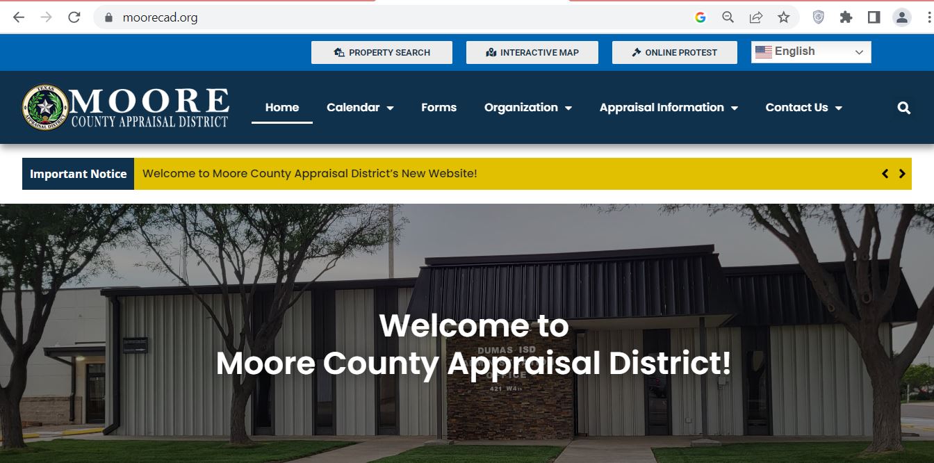
How to Use the Official Moore County CAD Screenshot
The supplied screenshot URL has been normalized to the expected image filename ending in Moore-County-CAD.jpg. Use the image to recognize the official Moore CAD site and its direct task buttons.
Official Moore CAD website reference image for property search, GIS and online-protest navigation.
1Verify the official website
Confirm that the browser shows moorecad.org before opening a search, creating a portal account or uploading documents.
2Select Property Search
This opens the BIS search at esearch.moorecad.org, where Owner, Address, ID, ARB Search and Advanced options are available.
3Select Interactive Map
Find the Property ID and Geographic ID first, then use the map to identify the general tract and adjoining accounts.
4Select Online Protest
The former eProtest page now sends taxpayers to the centralized Moore CAD Taxpayer Portal.
5Open Forms for live applications
Use current forms for homestead, agricultural appraisal, business property, protest and electronic-delivery requests.
6Save the exact account number
Use the same Property ID on forms, evidence labels, Tax Office searches and calls to district staff.
Best workflow: Search the appraisal account first, copy the identifying fields, confirm the parcel on GIS and only then continue to an exemption, protest, tax payment or deed search.
Choose the strongest search tab.
Use Owner, Address, ID or Advanced. ARB Search is useful for protest-status and hearing research.
Start with the Property ID when available.
Use the number from an appraisal notice, prior property report or tax statement.
Enter owner names as last name first name.
Try only the surname when a complete name returns no result.
Simplify an address search.
Use the main street name or street number plus name. Remove Road, Street, Avenue, Highway or directional wording when necessary.
Choose the correct property type.
The portal can separate Real, Personal, Mineral, Auto and Mobile Home property.
Use Advanced Search for rural or commercial accounts.
Fields include abstract, mobile-home park, DBA, subdivision, condo, Owner ID, Geographic ID, neighborhood, tax year, agent and protest details.
Open every plausible result.
One owner can have a residence, irrigated acreage, feedyard, grain facility, mineral account, mobile home and business-personal-property account.
Confirm the 2026 record status.
Check whether the current-year value is preliminary or certified before using it for a closing or final tax estimate.
Save a dated property report.
Keep the report with forms, protest evidence, tax receipts and deed research.
Panhandle search tip: For property near Dumas, Sunray, Cactus, Etter or rural farm roads, Property ID, Geographic ID, abstract or owner searches often work better than a complete mailing address.
Five Fields to Match Before Using a Moore CAD Result
Property ID
Match the complete appraisal identifier.
Geographic ID
Use it to connect the record with GIS.
Legal description
Check abstract, tract, subdivision or lot.
Acreage or address
Confirm the physical property involved.
Property type
Verify real, personal, mineral, auto or mobile home.
Do not rely on the owner name alone. Businesses, trusts, farms and family ownership can produce several accounts with similar names but different property types and tax obligations.
Moore CAD Search Problems and Practical Fixes
Problem
Try This
Final Check
Full owner name returns no result
Use only the first or last name.
The account may use initials, a trust, estate, LLC or previous owner.
Recent purchaser is missing
Search the seller or prior owner.
Compare the CAD owner with the newest recorded deed.
Rural address fails
Use Property ID, Geographic ID, abstract or owner.
The CAD situs may differ from the postal or emergency address.
Too many results appear
Add property type, subdivision, neighborhood, tax year or acreage clue.
Open the record and compare legal description and location.
Mobile home is missing
Select Mobile Home or search the home owner and landowner separately.
The home and land may have separate Property IDs.
Business account is missing
Search the legal name, DBA, agent or property type Personal.
The account may be listed at the asset location rather than mailing address.
Mineral account is missing
Select Mineral and search owner, legal description or account clues.
Surface ownership does not prove mineral ownership.
Nothing can be matched
Call Moore CAD with the former owner, approximate location and legal description.
Ask staff to confirm the correct Property ID and property type.
“I am trying to identify the correct Moore CAD account. The present or former owner is ______, the property is near ______, and my deed, notice or tax statement shows ______. Can you confirm the Property ID, Geographic ID and property type?”
How to Read a Moore CAD Property Record
Field
Meaning
What to Verify
Property ID
The primary appraisal-account identifier.
Use the exact number on applications, evidence, calls and tax searches.
Owner ID
An identifier attached to an owner record.
One Owner ID can be connected with several properties.
Geographic ID
A location-oriented parcel identifier.
Use it for GIS and rural-land research.
Owner and mailing address
The owner displayed for appraisal and the address used for correspondence.
A mailing-address correction does not transfer legal title.
Situs address
The physical location used by the appraisal system.
Rural and industrial situs descriptions may differ from postal formatting.
Legal description
Abstract, survey, subdivision, lot, block or tract description.
Compare with the deed, plat and survey before legal use.
Land market value
Estimated market value of the land.
Acreage, location, access, irrigation, zoning, land class and industrial influence.
Improvement value
Value assigned to houses, shops, elevators, bins, tanks and other structures.
Size, age, quality, condition, use and removed improvements.
Market value
The district’s January 1 estimate of market value.
Compare with sales, income, cost and the property’s actual condition.
Appraised value
Value after an applicable statutory limitation.
A limitation does not automatically prove the market value is correct.
Agricultural value
Productivity value for qualifying open-space land.
Qualifying acreage, use, intensity, history and homesite separation.
Taxable value
Value remaining after applicable limitations and exemptions.
Check every taxing unit because exemption amounts can differ.
Legal-use warning: Moore CAD states that legal descriptions and acreage shown online are for appraisal use and should be verified before use in legal documents.
Moore County 2026 Appraisal Audit Checklist
Compare the 2025 and 2026 market values.
Separate land and improvement changes.
Confirm the Property and Geographic IDs.
Verify acreage and legal description.
Review living area and improvement measurements.
Check year built, quality and condition.
Look for added grain bins, shops, tanks or structures.
Confirm removed or damaged improvements were corrected.
Verify homestead and veteran exemptions.
Review agricultural productivity value.
Check business asset lists and depreciation.
Save photographs, estimates and comparable records.
Dumas residence
Compare similar homes by neighborhood, living area, age, condition, quality, lot size and recent sales.
Irrigated farm or ranch
Review acreage, water access, pivot irrigation, soil and land class, improvements, homesite and qualifying agricultural use.
Industrial or commercial property
Review land allocation, buildings, tanks, machinery, income, useful life, depreciation and environmental or access limitations.
2026 Value Limitations to Check
Residence-homestead limitation
A qualifying homestead limitation generally restricts annual appraised-value growth but does not freeze market value.
Non-homestead circuit breaker
Qualifying non-homestead real property valued at $5,320,000 or less may receive the temporary 20% limitation for 2026, subject to statutory exclusions.
Agricultural productivity appraisal
Qualifying open-space land is appraised using productivity rather than ordinary market value.
“Property ID ______ changed from ______ in 2025 to ______ in 2026. Please identify the land, improvement, agricultural, exemption, property-class or appraisal-limitation factor that caused the change.”
How to Use the Moore CAD Interactive GIS Map
Find the appraisal account first.
Copy the Property ID, Geographic ID, acreage and legal-description information.
Locate the general property area.
Use highways, farm roads, towns, industrial sites and adjoining parcels as location clues.
Match the selected parcel.
Compare the Property ID, owner, acreage, abstract and nearby ownership.
Check related accounts.
Large farms, feedyards, industrial facilities and mobile homes may span or connect with several Property IDs.
Save a dated screenshot.
Label it with the Property ID and use it only as a research or protest exhibit.
Use legal and professional sources before acting.
Obtain deeds, title research and a survey before fencing, buying, dividing or resolving access.
GIS can help identify
General parcel location
Adjoining appraisal accounts
Farm and section layout
Road and subdivision context
Properties without a complete address
GIS cannot prove
Exact surveyed boundaries
Clear title or legal access
Mineral ownership
Official flood determination
Survey-quality acreage
Map disclaimer: The BIS map is informational and shows approximate relative locations. It is not a legal, engineering or surveying product.
How to Use the Moore CAD Taxpayer Portal and Online Protest
Moore CAD’s former eProtest page now directs taxpayers to the centralized Taxpayer Portal. The portal provides property details, electronic communication, important documents, applications and online appeals.
Search the property before registering.
Copy the Property ID, owner and legal description.
Select Sign Up.
Use an email account monitored during appraisal and protest season.
Complete the registration process.
The portal may display “Approval Pending” while Moore CAD reviews the enrollment.
Link the correct property.
Match the Property ID, owner and legal description before opting into communications or filing an application.
Review electronic-delivery choices.
An election for electronic communication remains in effect until rescinded in writing.
Save every confirmation.
Download applications, protest submissions, notices, messages and time-stamped receipts.
Deadline tip: Register before a protest or application deadline. A registration that remains pending does not automatically extend a statutory filing date.
Moore County Homestead and Property-Tax Exemptions
Exemption or Relief
2026 Starting Point
What to Prepare
General residence homestead
Texas school districts provide a mandatory $140,000 exemption.
Ownership, principal-residence information and required identification.
Age 65 or older
Qualifying owners receive an additional mandatory $60,000 school exemption.
Age, ownership and residence information.
Disabled person
Qualifying disabled owners may receive the additional school exemption and related protections.
Documentation accepted under the statutory disability requirements.
Disabled veteran or survivor
The benefit may be partial or total depending on the statutory category.
VA rating, service information and applicable survivor records.
Heir-property homestead
An occupying heir may qualify even when not individually listed on a recorded deed.
Ownership affidavit, death certificate, utility records and available court documents.
Tax deferral
Some age-65 or disabled owners may defer collection on a qualifying homestead.
Understand that the tax lien remains and interest may continue.
How to File an Exemption Application
Search and verify the property.
Confirm Property ID, owner, situs address and legal description.
Select the exact exemption.
Use the residence-homestead, disabled-veteran or other application that matches the qualification.
Complete every ownership section.
Include spouse, co-owner, trust, heir-property or manufactured-home information when applicable.
Attach all required documentation.
Follow the current form’s identification and proof requirements.
Deliver the complete packet.
Mail to P.O. Box 717, Dumas, TX 79029, or confirm an accepted in-person or electronic method.
Keep proof of filing.
Save the application, attachments and delivery confirmation.
Verify approval online.
Confirm that the exemption appears for the correct owner, property and tax year.
New-owner warning: The seller’s homestead exemption, appraisal limitation or tax ceiling does not automatically transfer to the purchaser.
Agricultural and Open-Space Appraisal in Moore County
Moore County includes irrigated cropland, grazing acreage, feedyards and agricultural support property. Qualification for 1-d-1 appraisal depends on principal agricultural use, local intensity and historical use—not only acreage or rural location.
Qualification Area
What Must Be Demonstrated
Useful Evidence
Principal agricultural use
Agriculture is the land’s primary qualifying use.
Crop, grazing, livestock, feed, production and sale records.
Degree of intensity
The operation meets locally typical intensity.
Planting, irrigation, stocking, feed, fencing, equipment and management records.
Historical use
The tract satisfies the statutory qualifying-use history.
Prior applications, leases, receipts, photographs and operator statements.
Leased operation
A tenant actively conducts the qualifying activity.
Signed lease, operator contact, crop records and grazing records.
Irrigated acreage
The land class and productive use reflect actual irrigation conditions.
Well records, pivot maps, energy records, crop history and repair documentation.
Homesite separation
Residential and nonqualifying acreage is separated from productive land.
Survey, aerial image and acreage breakdown.
Current 1-d-1 application
Property ID for every tract
Legal description and acreage
Map showing claimed agricultural land
Crop, livestock or grazing description
Qualifying-use history
Irrigation and production records
Lease when another person operates the land
Receipts and dated photographs
Homesite and nonqualifying acreage calculation
2026 agricultural cap rate: Texas appraisal districts must use a 10.00% capitalization rate for agricultural and open-space land in 2026.
Change-of-use warning: Development or another nonagricultural use may create rollback-tax consequences. Ask Moore CAD for current guidance before changing use.
Business Personal Property, Industrial Assets and Mineral Accounts
Business personal property
Machinery, equipment, furniture, computers, tools, vehicles, inventory, supplies and leased assets may require a rendition.
Industrial property
Grain facilities, feedyards, processing property, tanks, utilities and other specialized assets may require detailed cost and depreciation records.
Mineral property
Mineral accounts may be separate from surface property and can involve fractional ownership, lease or operator information.
Business Rendition Checklist
Business legal and trade names
Moore CAD Property ID
Physical asset location
Asset descriptions
Original acquisition costs
Acquisition years
Disposed or retired assets
Leased equipment
Inventory and supplies
Authorized signature
Normal rendition timing: Most business-personal-property renditions are generally due April 15. A timely written extension normally moves the deadline to May 15.
2026 exemption: Qualifying income-producing tangible personal property receives a $125,000 exemption in each taxing unit. Contact Moore CAD before assuming no rendition or account update is required.
Depreciation research: Moore CAD’s Public Information page includes 2026 Pritchard & Abbott percent-good tables and current appraisal reports. Use the file that matches the asset class being reviewed.
How to Prepare a Moore County CAD Protest
July 2026 timing: The regular protest period has generally passed for owners who received timely spring notices. The exact deadline printed on the Notice of Appraised Value controls.
Usual Texas deadline
May 15 or 30 days after the appraisal district mailed the notice, whichever is later.
Controlling date
Use the date printed on the individual appraisal notice.
Electronic route
File and manage available appeals through the Taxpayer Portal.
Hearing research
The appraisal search includes ARB Search and hearing-related fields.
Issue
Evidence That Helps
Weak Argument to Avoid
Residential market value
Comparable sales, appraisal, repair estimates, photographs and condition records.
Only saying that the tax bill increased.
Unequal appraisal
Comparable CAD accounts adjusted for location, size, age, quality and condition.
Using one unrelated property with a lower value.
Acreage or property data
Deed, survey, measurements, photographs and improvement-removal records.
Using only an approximate GIS line.
Agricultural appraisal
Use history, crop records, leases, irrigation records, grazing evidence, maps and photographs.
Saying only that the property is rural.
Business or industrial value
Asset lists, cost, age, condition, depreciation, disposal records and income information.
Submitting no account-specific asset detail.
Mineral account
Ownership interest, lease data, production, operator information and valuation analysis.
Comparing mineral value with the surface property.
Moore CAD Protest Micro-Steps
Read the Notice of Appraised Value.
Record the Property ID, proposed value, reason for change and exact deadline.
Save the property report.
Review land, improvements, exemptions, classifications and prior-year history.
Separate each protest reason.
Treat market value, unequal appraisal, data errors, exemptions and special appraisal as distinct issues.
State the requested result.
Identify the value, classification or exemption outcome you believe is correct.
Open the Taxpayer Portal.
Use portal.moorecad.org for available online appeals.
Upload labeled evidence.
Name files clearly with the Property ID and exhibit number.
Save proof of filing.
Keep the confirmation, submitted form and every portal message.
Prepare a one-page hearing outline.
List the requested result, strongest facts and exhibit references.
“I am reviewing Moore CAD Property ID ______ for tax year 2026. My notice shows a deadline of ______. Please confirm the accepted filing method, evidence procedure and current hearing status.”
What to Do After the Regular Protest Deadline
Good-cause late protest
Ask whether the ARB can hear a late protest before the appraisal records are approved.
Required notice was not received
Explain when the issue was discovered and which mailing address Moore CAD used.
Clerical or ownership error
Ask whether an appraisal-roll correction applies to the specific mistake.
Substantial over-appraisal
Limited correction procedures may apply when statutory value and payment requirements are met.
Late exemption
Certain homestead, age-65, disability and veteran filings have special late provisions.
Taxes remain unpaid
Contact the Tax Office separately because an appraisal inquiry does not automatically stop delinquency.
Act promptly: Give Moore CAD the Property ID, tax year, notice history, exact error and current payment status. Late remedies are limited and fact-specific.
How to Search and Pay Moore County Property Taxes
The Moore County Tax Assessor-Collector provides a dedicated property-tax search and directs online payments through Certified Payments using bureau code 3715430.
Choose Owner, Address, ID or Advanced.
Use the Property ID or tax-account number from the statement when available.
Shorten the search when necessary.
Use only the surname or main street name if a complete search fails.
Open the exact tax account.
Match the owner, Property ID, legal description, situs and property type.
Review all unpaid years.
Check current tax, earlier years, penalty, interest and any collection charges.
Confirm the complete payoff.
Contact the Tax Office before paying when the account is delinquent, under litigation or subject to an installment arrangement.
Normal Texas deadline: Property taxes are generally due by January 31 and become delinquent February 1 unless a different statutory date applies.
Payment safety: Do not enter banking information until the agency name and bureau code match the Tax Office’s current official instructions.
“I need the complete payoff for Moore County tax account ______ through ______. Please confirm all unpaid years, penalty, interest, collection charges, payment options and the correct bureau code.”
Taxing Units That May Appear on a Moore County Account
The exact combination depends on the property’s physical location and jurisdiction boundaries.
County entities
Moore County general, road-related county funds and Moore County Hospital District may appear.
School districts
Dumas ISD, Sunray CISD and another district with territory in Moore County may appear by location.
Cities
City of Dumas, City of Sunray or City of Cactus may appear when the property lies inside municipal boundaries.
College district
Amarillo College’s Moore County-related taxing jurisdiction may appear on applicable accounts.
Water districts
North Plains Groundwater Conservation District or Palo Duro River Water District may appear.
Who answers what?
Ask Moore CAD about taxable value and exemptions; ask the taxing unit about its adopted rate.
How to Search Moore County Deeds, Liens and Recorded Documents
The County Clerk links an online Public Inquiry system. The office states that staff generally do not conduct public record searches except searches specifically authorized by law, so users should search directly or use a title professional.
Save the Moore CAD property information.
Copy the owner, Property ID, legal description, abstract, subdivision, lot and tract.
Search limitation
Clerk staff do not guarantee or perform general title and lien searches for the public.
Title warning: One matching deed does not prove that no mortgage, easement, tax lien, probate matter, mineral reservation or later filing affects the property.
Moore County Buyer and New-Owner Checklist
Appraisal account
Property and Geographic IDs
Owner and mailing address
Legal description
Acreage and land class
Building and asset details
Every related account
Taxes and exemptions
Current tax balance
Prior-year taxes
Penalty and interest
Homestead status
Agricultural value
Deferral or installment status
Title and land research
Latest recorded deed
Liens and releases
Mineral reservations
Easements and access
Survey and acreage
Water, environmental and flood research
Future-tax warning: Do not estimate your future bill only from the seller’s current taxes. Homestead limitations, exemptions, agricultural appraisal and ownership changes may alter the taxable value.
Practical Moore County Property Scenarios
Dumas residence
Check living area, homestead exemption, Dumas ISD, city jurisdiction and any new improvements.
Sunray property
Verify city limits, Sunray CISD, water-district jurisdiction, account type and every adjoining parcel.
Cactus property
Confirm city jurisdiction, school district, industrial influence and the correct mailing and situs addresses.
Irrigated cropland
Match every tract, pivot area, irrigation records, land class, homesite and agricultural-use history.
Feedyard or grain facility
Review land, buildings, bins, machinery, inventory, depreciation and separate business accounts.
Inherited property
Compare the CAD owner with probate and recorded deeds. Changing the mailing address does not transfer title.
Moore County Property Office Contacts
Search, values, exemptions and protestsMoore County Appraisal District
419 Success Blvd.
Dumas, TX 79029
Use live official records
Return to the responsible official portal whenever you need a current owner, value, tax balance, deadline, map or filing status.
Moore County CAD Property Search FAQs
1. What is the official Moore County CAD website?
The official Moore County Appraisal District website is MooreCAD.org. Its direct property-search website is eSearch.MooreCAD.org.
2. Where is Moore County Appraisal District located?
Moore CAD is located at 419 Success Boulevard, Dumas, Texas 79029. Its mailing address is P.O. Box 717, Dumas, Texas 79029.
3. What is the Moore CAD phone number?
The main Moore County Appraisal District phone number is 806-935-4193. The district’s listed fax number is 806-935-2792.
4. Who is the Moore CAD Chief Appraiser in 2026?
Moore CAD’s current official website and a May 2026 Appraisal Review Board notice identify Janie Starkey, RPA, as Chief Appraiser.
5. How do I search Moore County property records?
Use the official search and choose Owner, Address, ID or Advanced. Advanced fields include abstract, property type, DBA, subdivision, Owner ID, Geographic ID, neighborhood, tax year and protest information.
6. What property types are available in the Moore CAD search?
The property-type filter can include Real, Personal, Mineral, Auto and Mobile Home accounts. One owner may have several separate property types.
7. What are the 2026 Texas school homestead exemptions?
Texas school districts provide a mandatory $140,000 general residence-homestead exemption. Qualifying owners age 65 or older or disabled receive an additional mandatory $60,000 school exemption.
8. How do I file a Moore CAD online protest?
Use the Moore CAD Taxpayer Portal at Portal.MooreCAD.org. The district’s former eProtest page states that online protests have moved to the Taxpayer Portal.
9. Where do I pay Moore County property taxes online?
Search the property through eSearch.co.Moore.tx.us, then follow the Tax Assessor-Collector’s Certified Payments instructions. The county page lists bureau code 3715430.
10. Is the Moore CAD GIS map a legal property survey?
No. The GIS map is an appraisal-location tool showing approximate relative parcel locations. It does not replace a recorded deed, title examination or professional boundary survey.
Independent Guide Disclaimer
County-CAD.org is an independent informational guide. It is not affiliated with Moore County Appraisal District, the Moore County Appraisal Review Board, Moore County Tax Assessor-Collector, Moore County Clerk, BIS Consultants, Certified Payments, any taxing unit or the State of Texas.
Property values, exemptions, deadlines, office personnel, office hours, portal availability, account balances, payment charges, forms and tax rates can change. Confirm time-sensitive information with the responsible official office before filing, paying, mailing documents, purchasing property or taking legal action.